|
Both Rentals , the Cabin and the Mobile home here in Abbot are located near the surrounding towns ; Cambridge Corinna,
Dexter, Dover-Foxcroft, Exeter, Garland, Greenville, Guilford, Harmony, Monson, Parkman, Ripley, Sangerville, Shirley, St.-Albans
and Wellington

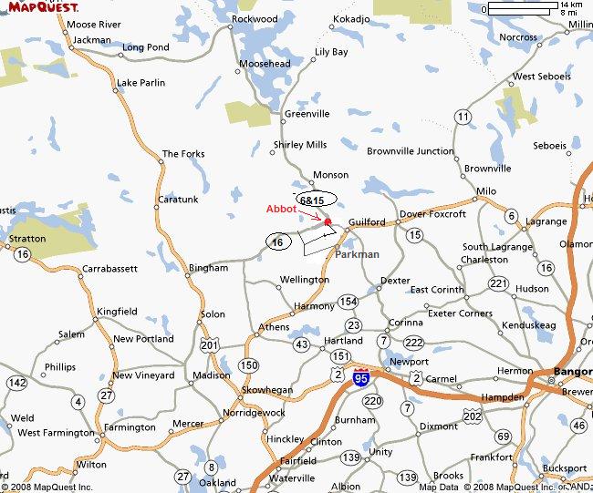
Here are a couple of maps that will have to do till I find better
ones. These maps with these driving instructions will get you here . Keep in mind that the road I live on used to be Back
Parkman Rd.& Crow Hill Road & Perkins Road - it is now Monument Road . DO NOT USE MAPQUEST or Yahoo , they have no idea where Abbot (ABBOT VILLAGE ) is !
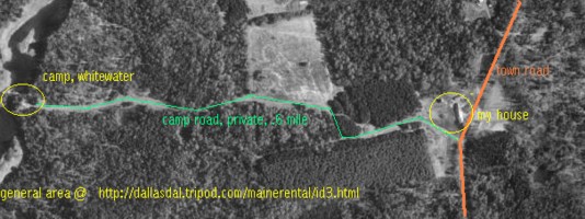
The
vehicle access to the camp is only through my back yard. (I suggest that while you here in Maine you purchase The Maine Atlas
and Gazetteer, shown below, it is probably the best all around map of Maine ... but I have one at the camp you can use )
The camp itself is located on the map page 31 at about 1-8 of an inch north-east and the opposite side of the stream as the
entrance of Lowell Brook into Kingsbury Stream.
Abbot is 32 miles from Newport.
.. Coming from southern Maine, I suggest you go to Newport, Maine,
at mile 157 and is now EXIT 157 (, used to be exit # 39 .) then take route 7-11 towards Dexter. Stay
on route 7 You will pass through (Newport -Corinna and Dexter)
In Dexter take a left about 600 feet
past the only traffic light onto route 23 to (through) Sangerville, ( note you may see 2 Route
23 signs - You want the second Route 23, the one that goes NORTH ) THAT SECTION IS ABOUT 12 MILES to Sangerville
After passing through Sangerville ,,then take a left on to routes 6-15-16 (route 23 ends at this intersection ) (
6 -15- 16 is one road) through Guilford to Abbot. While in Guilford , you will cross over another bridge, take a sharp right
there , toward Abbot and Greenville direction ( routes 6 - 15 - 16 )
Abbot is 3.6 miles further ( <3 point 6 ) if you have your gps unit
turned on again - Dont take the Gale Road between Abbot and Guilford.
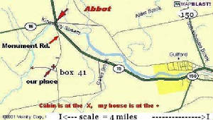
Take a left onto the Monument Rd.
( this will be before you cross a cement bridge on a slight corner , there is a 22 foot granite statue, on your left, at the
intersection of 6 - 15 - 16 and the Monument Road.
...Once you arrive at my house, Mailbox # 41, it is .8th of a mile from the monument. (It
is white, on your right, and 120 feet long) Please stop at my house to introduce yourself..... And let us know if you are
expecting any other vehicles to drive to the camp . This is important so I don't have to chase them down , I want you to have
an interrupted stay . Should you need it my Ph. # is 207 876 2639
... The most common error, following these instructions, is that people take Route 16 once they get to Abbot.
(wrong road
DONT STOP at the first Patterson sign you see , go to my house at mailbox 41,
it is exactly .8 of a mile
my phone number is 207 876 2639 and if
you let me know your estimated time of arrival , Ill stay near the phone The closest airport is Bangor (BGR )
|
|


People in Maine commonly buy a new Atlas every year, because they know it will show road and bridge washouts, new
logging roads and other types of up-to-date information. The Maine Atlas and Gazetteer by Delorme sets the standard for all
of our atlases in terms of backroad and backcountry detail. In addition, it pinpoints the locations of features like State
Parks, waterfalls,Senic Areas, hiking trails, ranger stations, forest gatehouses, lookout towers, lean-tos and
seaplane bases. It also contains street maps for 23 cities and towns. The scale is 1:125,000 (1" to 2 miles) WITH THIS MAP
YOU CAN PLAN and UTILIZE your vacation to the best it can be! Click on the map for purchase info . I try to keep one
at the cabin free to use .
Inclosed below is include a link to the current weather conditions at our vacation spot
below.

|
| 10 day weather forecast for ABBOT VILLAGE |
|
 |
| Locater My cabin ( X ) residence ( ) |
|
| Please stop at my house on your CHECK - IN |
|