|
Things to do list
Hiking In the Moosehead Lake Region
The Lake:
More than 40 miles long and up to 10 miles
wide, Moosehead Lake is the largest freshwater lake situated inside a single state in the northeast. From Greenville or Rockwood,
you'll view Mt. Kineo (1,806 ft) at it rises from the Lake. Comprised of flint, Indian tribes traveled great distances to
make tools and weapons.
( the State has renamed this mountain to big Moose mountain )
At 3,196 feet, Big Squaw Mountain, with a long ridge line, dominates the view
to the west from the Moosehead area. The view from the top of the mountain is famous for beholding the Moosehead region and
its many lakes and mountains. this mountain was home to the first fire tower in the United States, built by M.G. Show in 1905.
From the
Ski lift they run the chair lift in late summer and fall for senic views from the top Contact # 207 695-1000
Directions from Greenville: Travel approximately 5.3 miles
north on Route 15. Take a left on the dirt road directly across from the Forest Fire Danger level sign. (Just past the Maine
Forest Service Squaw Brook Campground.) Travel a little less than a mile on this road. Look carefully for a sign on the right,
which marks the trailhead.
Time: Round trip is approximately 7.5
miles, Allow up to 5 hours. when on top, proceed a short distance ahead to a ledge with a view of Mirror Pond. There is a
2,000 foot elevation change from the base to the top.]
=========================================================
This is a very beautiful hike. You will pass three very picturesque mountain
ponds in a distance of only four miles.
Directions: You have two choices for hiking this lovely area.
- Follow the same directions for the Big Squaw Mountain hike. Follow the road
beyond the Big Squaw trail head to the Y to the gravel pit. You will see the post headings of the trail approximately 1/2
mile from the gravel pit. Follow the trail to the edge of Little Squaw pond. Papoose Pond will be on your left. After Papoose
Pond, you may follow the trail to the left which ends behind the Greenwood Motel (will need a shuttle back) or you may follow
the trail to the right which will take you around Little Squaw Pond. If you continue to bear right, you will come back down
between the two Squaw Ponds. At the top of the right hand turn, if you turn around, you will note a spectacular view of the
south and the east. (This portion of the trail is the most difficult and should be approached only from the south
to the north, unless you are a seasoned hikers. From north to south it is a very steep, uphill climb.).
If you choose to follow the trail straight ahead, you will have a relatively
easy hike to Little Notch Pond (approx. 25 minutes)This trail ends just beyond the pond, therefore you will have
to turn around and return to the downhill trail on the left, between the Squaw Ponds to return to your starting point.
Time: This entire trip will take you between 3-½ and 4 hours
depending upon your hiking speed and ability. Begin your hike behind the Greenwood Motel (it is OK to park in their lot) just
north of Greenville on Rt. 15. This hike ends on the Scott Paper logging road approximately 1 mile from the trailhead of Big
Squaw Mountain. The trail from the Motel to Big Squaw Pond is approx. 4 miles. It ascends over Little Squaw Pond to Big Squaw
Pond. A car shuttle or pickup can be arranged with the proprietors of the Greenwood upon request .
==============================================
Borestone Mountain At 1, 947 feet, this is a small, but rugged mountain
with a bare summit and two peaks.. This is a great family hike. Borestone's last timber harvest was in 1899
making it attractive habitat for certain wildlife. Some of Maine's most coveted warblers spend their summer here—Blackburnian,
Cape May and bay-breasted nest in the coniferous canopy. Goshawks wing through the mature deciduous woods to prey on grouse.
Pine martins are regularly seen by sanctuary staff. Tree cavities provide nesting sites for raccoons, owls, woodpeckers
and other species—sometimes in succession—while eagles, falcons and turkey vultures also can be seen soaring overhead.
Total hiking distance is only four miles.
Borestone Mt. in central Maine
, Elliotsville TWP,about 18 miles from Abbot.
It is an impressive mountain (El. gain of 1100 ft) that rises abruptly beside
Lake Onawa . The trail ascends steadily to 3 ponds near the summit (Sunrise, Mid-day, Sunset Ponds) and then through the woods
to bare ledges and a panoramic 360 degree view. A trailside nature center located on the shore
of Sunrise Pond includes interactive displays and information about the area’s natural and human history. Hiking
time is est. at 3 1/2 hours round trip.
Directions: Reach the trail by driving south from Greenville
on Rt.15 to within 1/2 mile north of Monson village. Take a left on the Elliotsville Road (look for the Appalachian
Trail sign). Proceed ahead 8 miles to Big Wilson Falls. (A beautiful waterfall can be seen by going left before the bridge.
Its just a few feet from where you can park.. there are some fire-rings there for cooking .. there may be picnic
tables.) Cross bridge and take next left. Cross the railroad tracks. Trail is approximately .1 miles on the right up a private
road. Park on the main road, on the left. A small fee may be charged by the Audubon Society property caretaker. The society
owns the land around Borestone. They have developed interesting nature stations along the trail.
====================================================
|
|
| Onawa Trestle height 130 feet |
Onawa Trestle lies just a few miles from Borestone Mountain area.
The Onawa trainTrestle is the longest, highest railroad viaduct in Maine. The current carrier, Montreal-Maine-Atlantic
Railroad, operates trains on a highly unpredictable schedule over this trestle posted for "no trespassing".
The 1200-foot long Onawa Trestle crosses 130 feet above the Ship Pond Stream gorge, from Borestone Mt. head back
out towards Wilson Stream and then take the road towards Onawa village ( a few camps
on the lakes frontage) once you find the railroad tracks, continue on by vechicle till you see
the same tracks at a second road crossing , park nearby, follow the tracks south ( on foot) about
1/2 mile. . Great views of the tresle, Borestone Mountain and Onawa Lake
Big Spencer Mountain
The view from the top of this prominent
Moosehead landmark is truly outstanding. This is a challenging hike to a manned Forest Service firetower.
Directions: To get to the trailhead, drive
to Kokadjo 20 miles north of Greenville, on the Lily Bay Road. From Kokadjo, drive 5 miles (be sure to take the left fork
.2 miles north of Kokadjo) to the Georgia Pacific Paper Company gate, where a small fee will be charged. Proceed ahead approximately
3 miles to the Maine Forest Service Bear Brook Campsite on the right. Take the next left on a well used dirt road. Proceed
ahead for approximately 6.5 miles to the trailhead on the left. Look for a sign. Park on the right, just beyond the trailhead.
Time: Allow up to 4 hours hiking time for
the round tip. This is an 3,230' peak with a 1,900' elevation change, the upper portion of the trail has some ladders placed
over steep sections.
=============================================
B-52 Hike: Elephant Mountain
- B-52 Hike - Easy Walk; Elephant Mountain:
- Site of B-52 bomber wreckage which crashed on Elephant Mountain
in 1963.
-
This is a somber memorial to the crash of a B-52 bomber
doing training maneuvers in 1963. All but two crewmembers perished, and those two spent a cold night in a blizzard on this
remote mountain before being discovered. The people of Greenville have preserved the site and the wreckage in honor of the
men aboard this flight. Each year in January, a group snowmobile ride is held to this site, and a memorial service takes place.
Time: about one
mimute from where you can now park a vechicle to the beginning of wreckage strewn up the hillside
Allow 20 - 45 minutes looking time. there are foot paths , not accessable by
wheelchair
Difficulty: Easy
Directions: From the traffic light in downtown Greenville
drive north on the Lily Bay Road. At 7.1 miles look for a dirt road on the right (now marked as the Prong Pond Road). There will
be a yellow street sign showing a plane,( these signs are at most gravel intersections
) Take the right onto the dirt road and stay straight. at about 4.7 miles there is view of Elephant
Mountain before you and Baker Mountain in the north. Continue 1.2 miles further (5.9 total), crossing North Brook (campsite)
then go uphill where you will see signs marking the way and a sign at the trailhead which reads B-52 Memorial Site trail-
. Park here.
- ===================================================
Number Four Mountain This mountain provides a 2,890 foot
summit with a firetower. Although not a heavily traveled trail, the view offers a feeling of "being in the mountains".
Directions: To get to this trail, travel
approx. 17 miles north of Greenville on the Lily Bay Road. One mile south of Kokadjo, take the Frenchtown Road which parallels
First Roach Pond. This road is an obviously wide and well-traveled dirt road. Travel approximately 1.5 miles on this road.
Take a right and travel 1 mile. This road provides excellent views of Number Four Mountain and Lily Bay Mountain to your left.
Take the first left off this road and go .5 miles; trail is on the left after the first bridge marked by a sign. Parking is
across from the trail head on the right. Hake ahead on an overgrown road approximately ¼ mile to the site of an old wardens
cabin. The trail then ascends very steeply on a blue blazed trail.
Time: The round trip is approximately 2.5
miles. Allow 2-3 hours. Magnificent views from the top are rewarding.
================================================
Gulf Hagas (Check this one out!!!)
- Gulf Hagas:
- Appropriately nicknamed "the Grand Canyon of Maine", this
magnificent gorge is nearly 4 miles long, at times displaying vertical slate walls 300' to 400' deep. The west branch of the
Pleasant River drops some 400' within this four miles creating numerous waterfalls, chutes, and pools. The falls are particularly
spectacular during the spring runoff. This is also a must trip in the fall during the peak of the foliage season. The summer
offers tempting swimming holes under waterfalls. This is truly one of the most spectacular gorges in all New England and a
highly recommended hiking trip. The gorge and adjacent land has recently been purchased by the national Park Service. "The
Hermitage" (a majestic stand of towering white king pine) was declared a registered National landmark in 1968. This land is
now owned by the Nature Conservancy.
Directions: Access from Greenville. Take
a right at Sanders Store in Greenville (Pleasant Street) and continue straight ahead for approximately 2 miles. At this point,
the road takes a sharp right angle turn. Continue ahead on a dirt road approximately 10 miles, where you will come to the
hedgehog Checkpoint gate). Stop at the gate, pay a small fee (North Maine Woods Association). The attendant will give you
a map and directions to the head of the Gulf.
Time: Allow 6-8 hours for the hike which
includes a long trail of approximately 8.5 miles. To continue to "The Hermitage" would entail a round trip of 11.5 miles and
would require about 8 hours. If you do not wish to hike the entire trail, the head of the gulf can be reached by hiking only
1 mile from the trailhead. The Appalachian Trail passes through the Gulf. You will want to return to this spot time after
time!!!!
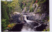
This is a picture of Billings Waterfalls at Gulf Hagas provided by Nicole & Dave
Little Spencer Mountain This hike is considered difficult
for the average hiker. Caution should be exercised. There is a flagging tape trail through the woods. The beginning of the
trail is somewhat wet and then becomes very steep and strenuous, although not a technical climb. Footing can be somewhat difficult
on steep portions due to loose shale rock.
Directions: Follow directions as for Big
Spencer Mountain to Kokadjo. At the first fork in the road, take the left fork to Spencer Pond Camps. 2.1 miles from the corner,
take the road on the right. This road will take you along the east shore of Spencer Pond. Approximately 1/2 mile on the right,
you will spot the flagging tape which marks the trailhead. There is a book at the summit of the mountain to sign.
Time: 4 hours for round trip
========================================
Mt. Kineo if you get a chance to , rent a boat in Rockwood and be
sure to go to the backside of Kineo by water (you won't forget this sight) a boat will cost between $35 and $140
(shop around) but if you are just here for the hike there are water Taxi's to take you over.
- Mt. Kineo:
- Located on a peninsula in the center of Moosehead lake, Mt. Kineo
rises dramatically 800 feet straight up out of the water on its southeastern face. This famous landmark can seen by driving
20 miles north of Greenville on Rt. to Rockwood.
- To get to Kineo from Rockwood, you must go by boat. Two
trails, the Indian Trail and the Bridle Trail, lead to the top. At the top, one can continue from the fire tower to North
Trail and Hardscrabble Point approximately 1-¾ miles and continue east on the Carriage Road Trail 1-½ miles to make a loop
hike back to the Bridle Trail. Once on the peninsula, do not head straight to the base of Kineo as the trail disappears and
is closed Proceed by heading northwest along the shore path from the docking area. Passing under the spectacular cliffs of
Kineo flint, it is approximately .8 miles to the Indian trail which starts on the right flagged by blue blaze. This trail
stays near the edge of the cliff all the way to the top which is reached in 1 mile. NOTE: This trail passes over steep
cliffs for extended lengths and adults should be in control of children at all times. Dramatic drop off all the way. Watch
closely for blaze marks to keep on trail. A short distance before reaching the firetower on top, you can continue east to
a trail which leads to the sheer faced cliffs... but be careful.
To reach the Bridle Trail, continue .3 miles northeast beyond
the Indian trail on the shore path. The trail is on the right by an old warden's camp. Although there are no views until the
top is reached, this is a longer, easier trail. The fire tower on top affords spectacular views and is well worth the climb.
Time: Allow 3 hours round trip from the
docking area.
=========================================================
Waterfalls in the area
These places below in red are nice senic
places near here
Bottle Brook Another
little set of waterfalls nestled in the hemlocks with a interesting rock formatiopn, , it is just about another
two miles toward Bingham from the road that goes into Kingsbury Falls. ( Or 9.6 miles from Abbot)
Our brooks are not named roadside so watch for the brook on the right side of the road (it crosses the road ) It is the only one with a 20 foot gravel bed on the right side of the road , they all look the same on the
left ! It also has a #200 (woods road number) nailed to a tree on the right side, now
that you found it walk downstream less than 5 minutes , I think for a small brook this might be the prettiest in the State,
-------------------------------------------------
WILSON FALLS and
GORGE Elliotsville Road, Monson, Maine
Little Wilson Falls is one of the highest falls in Maine, with the main drop being 13 yards. Long canyon below with many
scenic views. Trails are accessible by the Appalachian Trial. Wilson Falls has a wonderful Campground Area. There are wood
benches to have lunch on. . There are several walking trails from the lower Falls and camping area will take you to the
Wilson Gorge. It is about a 1-hour hike to the Gorge, but well worth the time. This trail is part of the Appalachian Trail,
so you may encounter some very personable hikers on your way.
Direction on getting there:
Follow Rt. 15 south towards Monson, from the Greenville area. Just
before entering Monson village, go left on the Elliottsville Road. Follow this road approximately 5 miles to Wilson Falls
campground on Big Wilson Stream. Turn left into the campground. Follow trails to Big Wilson Cliffs and Appalachian Trail to
Little Wilson Falls and Gorge.
Barrows Falls .. with in viewing distance of Barrors Falls Bridge
but there are good walking trails that follow either side downstrean serveral hundred yards .
See what water can do to rocks !!! Directions:
From Monson, take the Blanchard road to Blanchard
thjen a left towards Abbot. or from Abbot take the Whetstone Pond Road
=====================
WYMAN DAM
Up in Bingham , (west of Abbot ) look up Wyman Dam , As you come in Bingham from Abbot , take a right , right up the road is the town
of Moscow, just after entering Moscow near the school watch on the left for Signs that would lead you to the Dam ,
depending on the water flowage and the sun sometimes there are several rainbows
Also while in that area ,
look up Houston Brook Falls , I recently went there to check it out , Its is
on the other side of the dam / river. The upper falls consists of 5 short drops , the lower falls - the
biggest is bubblely water cascading over an 80 degree drop of about 35 feet . This is a short walk about 5 minutes
from the car . We passed this twice while looking for it , you will find a small sign and a parking place next to the
town Transfer Recycling Station To get to the other side, go back into Bingham cross the bridge on
route 16 , take a right follow the river upstream , its about a mile from the boat landing .
MOXIE
FALLS between Bingham and Jackman (at the Forks)
25 miles north of Bingham
It's one of the highest waterfalls in Maine.
Its about a one hour drive from Abbot , through
moose
country. Its located at the end of Moxie
Pond... It is about 100 feet at it's main drop,
there is a network of trails
and viewing platforms.
===================================================
In the first few pages of your
Maine Atlas and Gazetteer is the place to find all this stuff and lots more , State parks , sand beaches , historical
places Museums, nature preserves .
===========================================
A SCENIC TOUR (North )
Follow Route 6/15 north to Greenville,
nestled on the shores of 40-mile-long Moosehead Lake.
You could make your first stop in Monson on the way.
This town was once a major producer of Slate Blackboards, once used exclusively in schools, and slate was always used
extensively in the electrical field, whereas it doesn't conduct electricity. All older elevators used this material, until
the rise of plastics. Even in Monson there are 3 slate quarries, (open pits) several hundred feet deep. In other areas
just outside town (southeast ) slate was mined from shafts 700 feet down and then tunneled off to the sides.
This was usually done in steps on the way down , with each'' ledge , there was room for storage of the blasted slate
that eventually was taken to the top and processed." John Kennedy's grave marker came
from one of these areas. If you want to see one of these quarries , take the second right in town
(Water Street ) , then take the first left , go to Moosehead Manufacturing , you will see two quarries . ( Use CAUTION WHILE
THERE )
On the way to Greenville there are several well known
areas to see moose beside the road.
The area's tourism history dates to the 1890s, when you could
take a train from New York City directly to Greenville to enjoy the lake and the grand hotel at the base of Mount Kineo. Trains
to the region are a thing of the past, but this has not decreased the area's popularity - in summer, Moosehead Lake provides
swimming, boating and fishing grounds to a host of families and sportsmen and women.
As you might guess from its name, the Moosehead area boasts
a large population of moose; local guides offer Moose Safaris via float plane, canoe or kayak. These are nice trips , but
I cant imagine the local paying to see a moose,if they are not in the middle of the road,we don't stop to look at em'
During your stay in this neighborhood, visit the S/S
Katahdin, ( resverations for a cruise 1 207 695 2716 ) a gracefully restored 1914 steamship
that now serves as a floating museum. The "Kate" is one of the oldest steamships in America
and . also offers scenic tours of Moosehead Lake and passage to spectacular Mount Kineo, where you can hike, play
a round of golf on a scenic 9-hole course, or just explore the grounds of the once-grand Mount Kineo House.
1 207 695 2716
Is it lunchtime yet ?, STOP INTO the BLACK FROG
restaurant right in town
From Greenville, continue north on Route 6/15 to Rockwood ,
jusy before you get in town, stop at the FLYING MOOSE (its roadside on someones lawn ) and have your picture
taken . About another mile you will come to Rockwood, Great senic views of Kineo and Moosehead lake,
I think there are boat rentals in Rockwood as well as Beaver cove on the other side of the lake ,.
Mount Kineo has several trails to the top of it , if you
like hiking. from the water level on the North side you can drive a boat right up to towering 700 sheer rock wall that drops
into Moosehead Lake by another 300 feet . This mountain was known to the Indians for it's quality of flint, One of the
largest masses in the east. Flint rock was a valuable asset for fires and specifically arrowheads.
Continue on rt 6 / 15 to Jackman, where you can
canoe the popular (and very beautiful) 42-mile Moose River Bow Trip, which begins and ends at the same point.
Once you are in Jackman , its only another 25 miles to Canada
or 100 I think to Quebec City
From Jackman, take Route 201 - a designated State Scenic
Highway - south to The Forks, where the Kennebec River offers some of the most exciting whitewater rafting in the East. Several
local rafting companies provide gear, expertly trained guides, lodging and meals. (Ask about special packages for families
with children.) The Forks is also home to 96-foot Moxie Falls, accessible via a worthwhile half-mile walk.
From The Forks , its another 25 miles to Bingham ,
look up Houston Brook Falls there and Wyman Dam
Route 16 takes you back to abbot This is
a 150 mile round trip , probibily of seeing more than 6 moose!
=====================================================
Senic (South bound ) OK !!!!! who really wants to go south to see
the tourists , but here is a few places
Bangor - Brewer
for a daytrip south of here I recommend , in Bangor go see Stephen King's House on W Broadway, Bangor. Perhaps stop at Hollywood
slots on Main Street. A statue of Paul Bunyan is just across the street. Over in Brewer there is a fantastic
Chinese buffet restaurant ( about $5.
) Twin Chinese Buffet 274 State St ,
Brewer.
Fort Knox & the Penobscot Narrows Observatory : Prospect, Maine (..about 17 miles from
Brewer) . An OLD fort and a ultra modern bridge with an
elevator to its viewing tower ( 420 feet )
Located on the west bank of the Penobscot River in Prospect, Maine From Bangor:
On Rte. 1A South....follow Rte 1A South through the towns of Hampden, Winterport, Frankfort and Prospect. In Prospect Center,
take a left onto Rte. 174. Follow Rte 174 approximately 4 miles. Fort Knox will be on your left. On Rte 15 South....follow
Rte 15 South through the city of Brewer and the towns of Orrington and Bucksport. In Bucksport, take a right onto US Rte.1
South and proceed over the Penobscot Narrows bridge. Immediately upon exiting the bridge take a right onto Rte. 174. Fort
Knox will be approximately 1/4 mile up on your right
Go to Acadia national Park
,
check out the beaches ,Bar Harbor (tourist town ), Thunder Hole , drive up Mt Cadilac, and the carriage trails Mt Cadilac
is the highest point on the East coast ( just coast - not inlands)
Go to Belfast seacoast town fishing village and if the train is running take the short rideon Belfast
and Moosehead Lake Railroad at 1-800-392-5500. http://familyfun.go.com/travel/places/feature/famf199609_famf96train/famf199609_famf96train5.html
Then there WAS the CAT one of Americia's fastest car ferries on the water
at 55 MPH, daily trips to Canada leaves from Bar Harbor , you will want
at least two forms of ID , a birth certifate is a good idea , this is a great daytrip to Canada UPDATE-
March 21 2011 -The cat is no longer in service in this area, service terminated about jan 27 2011,
it was last seen passing through the Panama Canal, headed west but a new ferry is now
in service effective May 15,2014 the " NOVA STAR "

|
| Service terminated January 2011 |
Then there is the MAINE WILDLIFE PARK located in Gray, Maine on Rt. 26 207-657-4977 (
open from mid-April through Veteran's Day (Nov. 11).
Favorite Places:
The Hermitage Preserve-
Piscataquis County ,Greenville Bowdin College Grant East, 35 acres, Designated as a famous National landmark
in may 1977 . - One of the very few undisturbed old growth white pine stands left in all of New England.
Also contains hemlock and northern hardwood stands. Owner: Private
Big
Squaw Mountain (now Big MOOSE Mountain )- Greenville- Big Squaw TWP, 2000' elev gain, Views of Moosehead from
fire tower . (abandoned). Tourmaline, garnets and mica can be found at the summit.
Trails. 3 miles. Alpine & Nordic skiing.
Elephant Mountain- Greenville- Bowdoin College Grant West,
600' elev gain, Road to Baker pond. Crashed B-52 bomber on trail.
Gateway to the
Allagash Wilderness Waterway- Greenville
White Cap Mountain- Greenville, Bowdoin College Grant
East, 1600' elev gain, Fire Tower & trails with views of Mt Katahdin. 1 1/2 miles.
Little
Wilson Falls Gorge- Greenville- Elliotsville Twp, Little Wilson Stream, 300 yd gorge & walls 30 yds high.
Lily
Bay State Park- Beaver Cove- Park on Maine's largest lake. Mountains, fishing, campsites, picnic tables,
swimming area, boat launch (& rentals) and dumping station. Snowmobiling.
Mount Kineo-
Kineo TWP, 700' cliffs, Mountain peninsula protruding into the lake. Accessible by water only.to the public.
4 hiking trails and a lookout tower. Mountain biking trails, beach, and golf course.
Big Spencer Mountain-
Northeast Carry, Wels TWP- 1900' evel gain. Views of Katahdin, Moosehead region & Allagash lakes.
Trail to ranger's cabin. Fire tower ( may be manned). Base to summit 2 miles.
Number Four Mountain-
Kakadjo, Frenchtown TWP- 1700' elev gain. Views of Moosehead region. Base to summit 4
miles.
Peaks State Park- Dover-Foxcroft- Park located at Sebec Lake. Mountains, fishing, swimming, picnic
area, campsites, bathhouse & dumping station. Trails for hiking. ( there is a MUCH MUCH better
beach about 600 feet to the right of Greely's Landing, when you get to Greelleys Landing take the last right
hand road
.) it's Free too !
Barren Mountain- Onawa- Elliottsville TWP, 2200' elev gain, ATV and hiking trails
that pass by falls, gorge and caves. 4 1/2 miles.
Borestone Mountain- Onawa- Elliottsville
TWP, 1100' elev gain, Mounatin beside a lake. Trails. 2 miles.
Big Wilson Cliffs- Onawa- Elliottsville
TWP, 1000' elev gain, Slate outcrops have scenic views of the valley. Accessible by the Appalachian
Trail.
Slugundy Falls- Onawa- Elliottsville TWP, Long Pond Stream, Falls with a log suspension bridge.
Trails.
Little Wilson Falls- Onawa- Little Wilson Stream, Elliottsville Plt, One of the highest falls
in Maine (13 yards). Trails.
Gulf Hagas- Brownville Junction- West Branch Pleasant River, Bowdoin College
Grant "Grand Canyon of the East" and the Appalachian trail follows the edge, 3
mile canyon with 5 waterfalls. Walls are up to 40 yards high. Logs were once driven through the gorge.
Hay
Brook Falls- Brownville Junction- Bowdoin College Grant East, Cascades with 3 chutes.
Road access to Katahdin Iron Works. Trails.
Screw Auger Falls- Brownville Junction- Gulf Hagas Stream,
Bowdoin College Grant East, Appalachian trail stop.
West Chairback Pond Falls- Brownville Junction, TWP
7, West Chairback Pond Stream, 2 drops with a total of 18 yds.
Earley Landing Falls- Willimantic- Big
Wilson Stream, Two 2 yard declines. (only if you are in the area )
Tobey Falls- Willimantic- Big Wilson
Stream, 3 falls with a pool for swimming. Trails. (only if you are in the area
I have a number of requests about golf so I'll put that right here .. there are 3 nearby
golf courses, in order the closest is 5 miles away the other 2 are about 13 miles away ill just give the names
and you can use a search engine for details on each Piscataquis Country Club , Foxcroft Golf Club & Dexter Municipal Golf
Course
|